![](/images/other/stat-length.png)
![Randonnée Marche La Teste-de-Buch - LA DUNE DU PILAT - Commune de LA TESTE DE BUCH - Gironde - Photo](https://media.geolcdn.com/t/1900/400/ext.pjpeg?maxdim=2&url=https%3A%2F%2Fservices.sitytrail.com%2FGeolivesWS%2FDownloadMedia.ashx%3FTrailID%3D828953%26Media%3Dfix__20170914134900.jpg)
LA DUNE DU PILAT - Commune de LA TESTE DE BUCH - Gironde
AndreLACOMBE
Utilisateur
![Longueur](/images/other/stat-length.png)
Longueur
6,4 km
![Altitude max](https://static1.geolcdn.com/siteimages/upload/files/1508320355ic_sort_altitude_max_24dp.png)
Altitude max
81 m
![Dénivelé positif](https://static1.geolcdn.com/siteimages/upload/files/1508320355ic_sort_den_pos_24dp.png)
Dénivelé positif
194 m
![Km-Effort](/images/other/stat-length.png)
Km-Effort
9 km
![Altitude min](https://static1.geolcdn.com/siteimages/upload/files/1508320355ic_sort_altitude_min_24dp.png)
Altitude min
0 m
![Dénivelé négatif](https://static1.geolcdn.com/siteimages/upload/files/1508320355ic_sort_den_neg_24dp.png)
Dénivelé négatif
193 m
![Boucle](https://static1.geolcdn.com/siteimages/upload/files/16400158638029165_repeat_loop_refresh_sync_direction_icon.png)
Boucle
Oui
Date de création :
2018-04-16 22:51:26.254
Dernière modification :
2018-04-16 22:51:26.254
![Marche](https://static1.geolcdn.com/sitytour/trail-icons/101.png)
4h45
Difficulté : Facile
![Scannez ce code QR pour ouvrir la randonnée dans l'application SityTrail](https://capi.geolives.com/qq0zvz2zws4bq2lad0pu/sitytour/trails/828953/qr.png?size=200)
Application GPS de randonnée GRATUITE
À propos
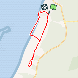
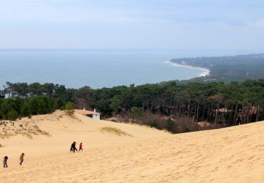
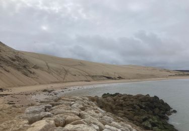
Randonnée Marche de 6,4 km à découvrir à Nouvelle-Aquitaine, Gironde, La Teste-de-Buch. Cette randonnée est proposée par AndreLACOMBE.
Description
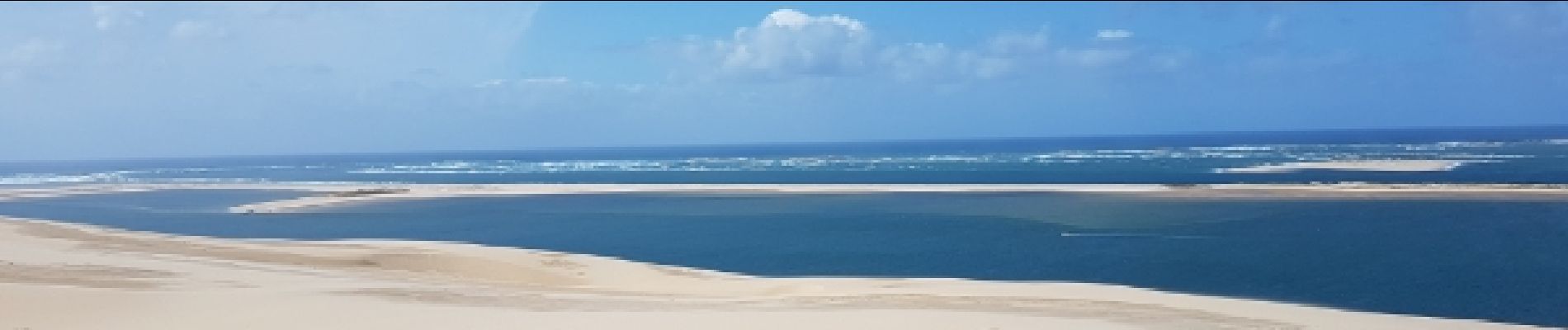
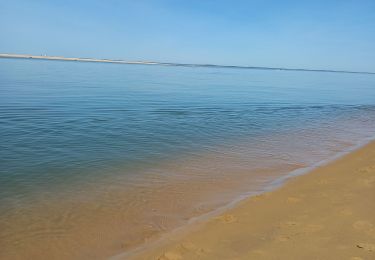
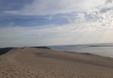
Parking et départ Avenue de la dune. Accès direct à mi-hauteur. Parcours sur la crête et retour par la plage.
Localisation
Pays :
France
Région :
Nouvelle-Aquitaine
Département/Province :
Gironde
Commune :
La Teste-de-Buch
Localité :
Unknown
Départ:(Dec)
Départ:(UTM)
642404 ; 4940250 (30T) N.
Commentaires
Randonnées à proximité
![Randonnée Course à pied Lège-Cap-Ferret - boucle du cap-ferret - Photo](https://media.geolcdn.com/t/375/260/ext.jpg?maxdim=2&url=https%3A%2F%2Fservices.sitytrail.com%2FGeolivesWS%2FDownloadMedia.ashx%3FTrailID%3D220061%26Media%3D20130908195551.jpg)
![Course à pied Course à pied](https://static1.geolcdn.com/sitytour/trail-icons/103.png)
boucle du cap-ferret
Course à pied
Très facile
(3)
Lège-Cap-Ferret,
Nouvelle-Aquitaine,
Gironde,
France
![](/images/other/stat-length.png)
11,5 km | 12,4 km-effort
1h 23min
![](https://static1.geolcdn.com/siteimages/upload/files/16400158638029165_repeat_loop_refresh_sync_direction_icon.png)
Oui
![Randonnée Vélo de route La Teste-de-Buch - Retour Vélo Arcachon 9.4.23 - Photo](https://media.geolcdn.com/t/375/260/98c12120-f5e1-44df-bbff-61c511944968.jpg&format=jpg&maxdim=2)
![Vélo de route Vélo de route](https://static1.geolcdn.com/sitytour/trail-icons/201.png)
Retour Vélo Arcachon 9.4.23
Vélo de route
Facile
La Teste-de-Buch,
Nouvelle-Aquitaine,
Gironde,
France
![](/images/other/stat-length.png)
13,1 km | 14,5 km-effort
1h 30min
![](https://static1.geolcdn.com/siteimages/upload/files/16400158638029165_repeat_loop_refresh_sync_direction_icon.png)
Non
![Randonnée Marche La Teste-de-Buch - Dune du Pilât 9.4.23 - Photo](https://media.geolcdn.com/t/375/260/5b1d8798-4488-43db-995c-a67f36ff4a4c.jpg&format=jpg&maxdim=2)
![Marche Marche](https://static1.geolcdn.com/sitytour/trail-icons/101.png)
Dune du Pilât 9.4.23
Marche
Moyen
La Teste-de-Buch,
Nouvelle-Aquitaine,
Gironde,
France
![](/images/other/stat-length.png)
4,7 km | 7 km-effort
2h 1min
![](https://static1.geolcdn.com/siteimages/upload/files/16400158638029165_repeat_loop_refresh_sync_direction_icon.png)
Oui
![Randonnée Marche La Teste-de-Buch - arcachon dune de pyla - Photo](https://media.geolcdn.com/t/375/260/eca80203-7459-4999-ac6a-1acafa65519d.jpg&format=jpg&maxdim=2)
![Marche Marche](https://static1.geolcdn.com/sitytour/trail-icons/101.png)
arcachon dune de pyla
Marche
Très facile
La Teste-de-Buch,
Nouvelle-Aquitaine,
Gironde,
France
![](/images/other/stat-length.png)
4,3 km | 5,9 km-effort
2h 4min
![](https://static1.geolcdn.com/siteimages/upload/files/16400158638029165_repeat_loop_refresh_sync_direction_icon.png)
Oui
![Randonnée Marche La Teste-de-Buch - les prés salés ouest - Photo](https://media.geolcdn.com/t/375/260/8d55b261-46ee-4fee-b4e3-b587276c9c55.jpg&format=jpg&maxdim=2)
![Marche Marche](https://static1.geolcdn.com/sitytour/trail-icons/101.png)
les prés salés ouest
Marche
Très facile
La Teste-de-Buch,
Nouvelle-Aquitaine,
Gironde,
France
![](/images/other/stat-length.png)
5,2 km | 5,4 km-effort
2h 1min
![](https://static1.geolcdn.com/siteimages/upload/files/16400158638029165_repeat_loop_refresh_sync_direction_icon.png)
Oui
![Randonnée V.T.T. La Teste-de-Buch - 2017-02-25 Forêt usagere de La Teste de Buch - Photo](https://media.geolcdn.com/t/375/260/ext.jpg?maxdim=2&url=https%3A%2F%2Fservices.sitytrail.com%2FGeolivesWS%2FDownloadMedia.ashx%3FTrailID%3D704929%26Media%3Dfix__20170225154401.jpg)
![V.T.T. V.T.T.](https://static1.geolcdn.com/sitytour/trail-icons/202.png)
2017-02-25 Forêt usagere de La Teste de Buch
V.T.T.
Moyen
La Teste-de-Buch,
Nouvelle-Aquitaine,
Gironde,
France
![](/images/other/stat-length.png)
16,9 km | 20 km-effort
3h 0min
![](https://static1.geolcdn.com/siteimages/upload/files/16400158638029165_repeat_loop_refresh_sync_direction_icon.png)
Oui
![Randonnée Marche La Teste-de-Buch - La Dune du Pilat - Arcachon - Photo](https://media.geolcdn.com/t/375/260/ext.jpg?maxdim=2&url=https%3A%2F%2Fservices.sitytrail.com%2FGeolivesWS%2FDownloadMedia.ashx%3FTrailID%3D316924%26Media%3D16030_3.jpg)
![Marche Marche](https://static1.geolcdn.com/sitytour/trail-icons/101.png)
La Dune du Pilat - Arcachon
Marche
Moyen
(1)
La Teste-de-Buch,
Nouvelle-Aquitaine,
Gironde,
France
![](/images/other/stat-length.png)
4,6 km | 6,7 km-effort
2h 0min
![](https://static1.geolcdn.com/siteimages/upload/files/16400158638029165_repeat_loop_refresh_sync_direction_icon.png)
Oui
![Randonnée Course à pied La Teste-de-Buch - truc de la truque 1 - Photo](https://media.geolcdn.com/t/375/260/ext.jpg?maxdim=2&url=https%3A%2F%2Fstatic1.geolcdn.com%2Fsiteimages%2Fupload%2Ffiles%2F1524743154running.jpg)
![Course à pied Course à pied](https://static1.geolcdn.com/sitytour/trail-icons/103.png)
truc de la truque 1
Course à pied
Très facile
(1)
La Teste-de-Buch,
Nouvelle-Aquitaine,
Gironde,
France
![](/images/other/stat-length.png)
11,4 km | 13,5 km-effort
5min
![](https://static1.geolcdn.com/siteimages/upload/files/16400158638029165_repeat_loop_refresh_sync_direction_icon.png)
Non
![Randonnée Marche La Teste-de-Buch - Dune du Pyla - Photo](https://media.geolcdn.com/t/375/260/3ffc653d-25d8-41a4-984d-5d30a957d895.jpg&format=jpg&maxdim=2)
![Marche Marche](https://static1.geolcdn.com/sitytour/trail-icons/101.png)
Dune du Pyla
Marche
Moyen
La Teste-de-Buch,
Nouvelle-Aquitaine,
Gironde,
France
![](/images/other/stat-length.png)
5,7 km | 8,1 km-effort
1h 47min
![](https://static1.geolcdn.com/siteimages/upload/files/16400158638029165_repeat_loop_refresh_sync_direction_icon.png)
Oui